


Sail Expert
Sailing App
คำอธิบายของSail Expert: Sailing App
แอปพลิเคชัน Sailing Expert มีดสวิสสำหรับนักเดินเรือ รองรับการนำทาง การแข่งเรือ ช่วยชาวเรือเก็บสมุดบันทึก แสดงพยากรณ์อากาศ เก็บบันทึกการบำรุงรักษาสำหรับเรือต่างๆ และอื่นๆ
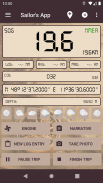
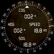
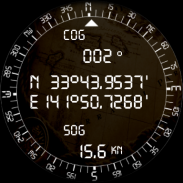
เซ็นเซอร์ของอุปกรณ์ใช้เพื่อกรอกบันทึก (ตำแหน่ง, COG, SOG, อุณหภูมิ, ความดัน)
หากมีผู้ให้บริการ WiFi NMEA ผ่าน WiFi เซ็นเซอร์ของเรือจะถูกใช้แทน รองรับทั้ง TCP และ UDP
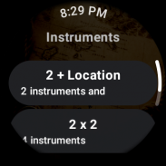
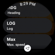
แอพนี้รองรับแอพคู่หูสวมนาฬิกา OS ที่แสดงเครื่องมือบนนาฬิกาของคุณ
โปรดดู
https://sail.expert/permissions
สำหรับวิธีที่แอปนี้ใช้การอนุญาต
ประโยค NMEA ที่รองรับ:
• GGA, GLL, GNS, RMC - การวางตำแหน่ง
• HDG, HDM, HDT, VHW - หัวเรื่อง
• VBW, VHW, VTG - หลักสูตร, ความเร็ว
• VLW - บันทึกการเดินทาง
• DBT, DBP - ความลึก
• RPM - รอบเครื่องยนต์
• MDA, MHU, MMB, MTA, MTW, MWD, MWV, VWR, VWT - Meteo/สภาพอากาศ
การนำทาง
แอปพลิเคชันจะบอกเส้นทางเป้าหมายหรือแจ้งเตือนหากคุณออกนอกเส้นทาง คำนวณระยะทางที่เหลือและเวลาถึงโดยประมาณ (ETA)
• เส้นทาง: ขณะล่องเรือ คุณสามารถใช้เส้นทางเพื่อนำทางได้
• เป้าหมาย: แก้ไขแบริ่งคอนกรีตหรือจุดสนใจเป้าหมาย (POI) ที่คุณต้องการแล่นเรือไป
• ทางเดิน: แอปพลิเคชันช่วยคุณวางแผนทางเดินโดยใช้วิธีกราฟระยะทาง-เวลา
• จุดเริ่มต้น: ในการแข่งเรือ แอปพลิเคชันช่วยให้คุณข้ามเส้นเริ่มต้นได้ตรงเวลาและด้วยความเร็วที่เหมาะสม
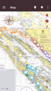
แผนภูมิ
• ข้อมูลแผนที่จากโครงการ OpenSeaMap หรือ NOAA RNC มีอยู่ในแอปพลิเคชันสำหรับการใช้งานแบบออฟไลน์
• เซิร์ฟเวอร์แผนที่แบบกำหนดเองสามารถใช้กับแอปพลิเคชันนี้ได้ (เช่น แผนที่ OpenStreet)
• สามารถนำเข้าไฟล์ MBTiles ในเครื่องได้
• แผนที่ที่สแกนสามารถนำเข้า ปรับเทียบ และตั้งค่าเป็นแหล่งที่มาของแผนที่
พยากรณ์อากาศ
พยากรณ์อากาศทั่วโลก (NOMADS GFS, DWD ICON Global และสถานที่ที่เลือก) สามารถดาวน์โหลดไปยังแอปและใช้ในระหว่างการเดินทางของคุณ
การเดินทาง
• สามารถเตรียมการเดินทางล่วงหน้าด้วยการเช็คอินและเช็คเอาต์ง่าย ๆ สำหรับเรือรับส่ง
• การเดินทางหรือชิ้นส่วนสามารถส่งออกเป็น CSV, GPX และ PDF ได้โดยตรงจากแอป
• ข้อมูลที่บันทึกสามารถเลือกที่จะซิงโครไนซ์กับ
https://sail.expert
• สามารถแชร์การเดินทางระหว่างอุปกรณ์โดยใช้การเชื่อมต่อ P2P ผ่าน WiFi
อื่นๆ
• ขณะอยู่บนจุดยึด แอปจะตรวจสอบตำแหน่งของคุณและเตือนคุณหากลอยออกนอกพื้นที่ที่ตั้งไว้ พื้นที่ดังกล่าวสามารถกำหนดค่าเป็นตำแหน่งและรัศมีหรือชุดของจุด (รูปหลายเหลี่ยม) สามารถตั้งค่าอุปกรณ์ที่สองเพื่อตรวจสอบสัญญาณเตือนภัยจากระยะไกลได้
• สามารถตั้งการแสดงอารมณ์อย่างง่ายเป็นเสียงเตือนในเครื่องมือต่างๆ
• คุณลักษณะคำแนะนำผู้ติดต่อที่เป็นตัวเลือกเมื่อเพิ่ม/แก้ไขบุคคลในแอป (ต้องได้รับอนุญาตจึงจะอ่านผู้ติดต่อของคุณได้)
คุณลักษณะและคุณลักษณะที่ผู้ใช้ร้องขอตามข้อเสนอแนะจากผู้ใช้ของเรา
• ส่งออกไฟล์ PDF
• แผนเส้นทาง (กราฟระยะทาง-เวลา)
• แก้ไขตำแหน่งด้วยตนเอง
• โค้ชความเร็วเสียง
• บันทึกการบำรุงรักษาเรือ
• สัญญาณเตือนภัยสมอเรือ
• การถ่ายโอนข้อมูลแบบ P2P ระหว่างอุปกรณ์
• ความช่วยเหลือในแอป (เฉพาะ EN)
• สำรอง/กู้คืน
คุณลักษณะอื่นๆ:
• NMEA ผ่าน WiFi
• พยากรณ์อากาศ
• รายละเอียดลม
• ภาพซ้อนทับแผนที่การเดินเรือ
• การนำทาง
• แผนที่ OpenSea
• แมนโอเวอร์บอร์ด
• เส้นเริ่มต้น
• หน่วย (เมตริก, จักรวรรดิ, ...)
• GPX, CSV ส่งออก
• เครื่องมือที่กำหนดค่าได้
แอปพลิเคชั่นนี้ไม่ต้องการการเชื่อมต่ออินเทอร์เน็ตหรือการลงทะเบียนใด ๆ สำหรับฟังก์ชั่นพื้นฐาน
เราขอแนะนำให้ผู้ใช้ของเรายื่นรายงานหากแอปพลิเคชันทำงานผิดปกติหรือขัดข้อง
สามารถส่งรายงานทางอีเมลไปที่ info@sail.expert
ขอบคุณมากสำหรับรายงานและข้อเสนอแนะทั้งหมด!
ดู
https://sail.expert
สำหรับรายละเอียดเพิ่มเติม
ไอคอนบางส่วนมาจาก:
- Icons8.com (https://icons8.com/)
- MatWeather (http://prithusworks.blogspot.com/2015/07/matweather-material-weather-icon-set.html)
- คอลเลกชันไอคอนแผนที่ (https://mapicons.mapsmarker.com)
Sail Expert: Sailing App--เวอร์ชั่น7.0.295
(19-02-2025)Sail Expert: Sailing App - ข้อมูล APK
เวอร์ชั่น APK: 7.0.295แพ็คเกจ: com.poterion.logbookเวอร์ชั่นล่าสุดของSail Expert: Sailing App
เวอร์ชั่นอื่น


 4.5
4.5


แอปในประเภทเดียวกัน

คุณอาจจะชอบ...


